Stadt El Cedral (Distrito Federal)
Informations
Zahlen
- Landesvorwahl :
- MX
- Postleitzahl :
- 16870
- Breite :
- 19.20822
- Länge :
- -99.12409
- Zeitzone :
- America/Mexico_City
- Zeitzonenbezeichner :
- UTC-6
- Sommerzeit :
- Y
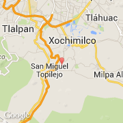
Die stadt El Cedral gehört zu der zustand Distrito Federal und zu der kommune Xochimilco.
Die stadt zählt El Cedral 150 Einwohner hat. Die maximale Höhe ist 5 m.
Die Einwohner werden Cedralense genannt.. Der spanische Name ist El Cedral.
©photo-libre.fr