Stadt El Pino (Chiapas)
Informations
Zahlen
- Landesvorwahl :
- MX
- Postleitzahl :
- 30934
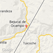
- Breite :
- 15.43333
- Länge :
- -92.11667
- Zeitzone :
- America/Mexico_City
- Zeitzonenbezeichner :
- UTC-6
- Sommerzeit :
- Y
Die stadt El Pino gehört zu der zustand Chiapas und zu der kommune Amatenango de La Frontera.
Die stadt zählt El Pino 871 Einwohner (Volkszählung von 2012) hat. Die durchschnittliche Höhe beträgt 660 m.
Der spanische Name ist El Pino.
©photo-libre.fr