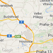
Stadt Kněževes (Hlavní město Praha)
Informations
Zahlen
- Landesvorwahl :
- CZ
- Postleitzahl :
- 252-68
- Breite :
- 50.12140
- Länge :
- 14.26146
- Zeitzone :
- Europe/Prague
- Zeitzonenbezeichner :
- UTC+1
- Sommerzeit :
- Y
Die stadt Kněževes gehört zu der region Hlavní město Praha, zu der distrikt Praha-západ und zu der kommune Středokluky.
©photo-libre.fr